In the 4th century BC, that of Pytheas, the geography of the world was centered on the Mediterranean. Outside the coastal strip, it was the unknown. Nevertheless, voyages were undertaken, towards the Indies and Africa.
In the 4th century BC, that of Pytheas, the geography of the world was centered on 1 638 / 5 000 At the time of Pytheas, in the middle of the 4th century BC, most travel took place in the Mediterranean. It is well known, even if the eastern part, the cradle of the Greeks, is mainly used. The Mediterranean is the center of the world. The world map is the one designed by Anaximander and Thales, barely corrected by Herodotus in the middle of the 5th century BC. The earth being round, it is very tempting for the scholars of the time to estimate its dimensions. The first may be Euxodes, a contemporary of Pytheas. He measures the difference in elevation of a star visible at two points, located on the same longitude, and whose distance he knows. He estimates the circumference at 400,000 stades, or about 80,000 km.
The regions explored, outside the Mediterranean and the Black Sea are as follows: Inland Africa is known by the Egyptians and is limited to the course of the Nile which was explored up to the 4th cataract. A voyage around Africa was ordered by Pharaoh Necho II, around the year 600. This exploration, extraordinary for the time, and which was done in 3 years, did not have the "scientific" support it deserved. The Middle East has been well known for many centuries. India has been recognized up to the Indus. Alexander the Great, through his admiral, went around it.
The Phoenicians created a trading post since the 10th century BC at the mouth of the Pillars of Hercules, on the Atlantic side. This is the city of Gadir (Cadiz today), located at that time on an island. From there they explore the coasts of Morocco and trade with the local barbarians.
.
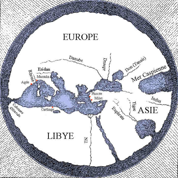 |
Map of the world that Pytheas had at his disposal during his journey. By observing the mouth of the Nile, on the Atlantic side which is south/north, we can deduce that Euthymenes, who first described it, went as far as the Niger River |
A Carthaginian named Hannon, according to information transmitted on a manuscript dating from the Xth century, towards the end of the Vth century, sailed down the coasts of West Africa, as far as the Gulf of Guinea, and perhaps even as far as Cameroon.
Around the Vth century, a navigator, perhaps from Marseille, named Hamilcon (cited by Pliny, but especially in a long story copied many times, “Ora Maritima” by Avenius), is said to have made a long 4-month journey in the Atlantic Ocean. Did he reach Cape Finisterre, the extreme northwestern tip of Spain, but also sailed offshore in the ocean, towards the Sargassum? He may have gone as far as Brittany.
Around +450 BC, a Massaliote (from Marseille) named Euthymenes, whose statue adorns the left facade of the stock exchange palace, embarked on a journey to the South Atlantic. He said that the Atlantic was cold and he observed creatures like those of the Nile. According to him, the Nile is born from the Atlantic by observing the force of the waves entering a river. How far did he go? To the mouth of the Senegal, or further to that of the Niger? Or did he simply repeat what he heard? Unlike Pytheas who would leave 100 years later, he must have been bothered by the lack of contact with the natives, and by the weak commercial appeal.
Concerning the interior of Europe, in the 4th BC, it was simply total ignorance. The Greeks, Phoenetians and Etruscans are essentially seafarers, and although they trade with the "barbarian" peoples, their explorations do not go beyond the coastal strip. This is how the Danube is supposed to have its source in the Pyrenees! Northern Europe is rounded, and comes to join the Indies. The entire northern part is uninhabited, because it is too cold. Our ancestors traded with the barbarians to obtain tin, amber, but also gold and furs.